Peel Mining
May Day Project
Project Snapshot
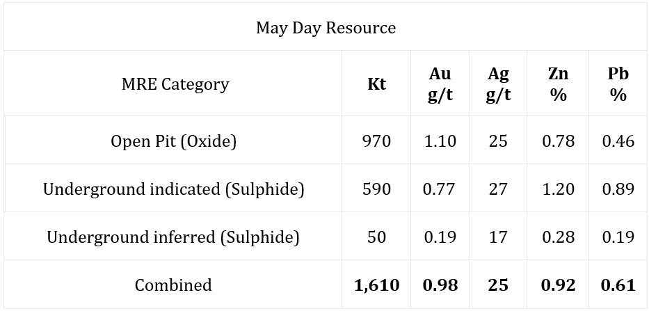
Mineral Resource January 2023
1.61 million tonnes at 0.98 g/t gold, 25 g/t silver, 0.92% zinc and 0.61% lead containing approximately 51,000 ounces of gold, 1,300,000 ounces of silver, 14,800t zinc and 9,800t lead.
The May Day Pit is located approximately 105km south-southeast of Cobar in western NSW, and was established targeting the gold-silver-copper-lead-zinc deposit in the late 1990’s. The deposit is situated within Mining Lease 1361, which was initially granted to Imperial Corporation Limited in 1995, with Peel Mining obtaining the lease in November 2009.
The May Day Pit was excavated in the late 1990’s by Jason Mining to a depth of approximately 50m below surface, using the experimental Vitrokele recovery process, with approximately 2,398 ounces of gold recovered during production. Gold recovery occurred from approximately 81,000t of high grade ore averaging 3.35 g/t Au, and 102,000t of lower grade or averaging 1.3 g/t Au (exact figures unknown due to experimental recovery process).
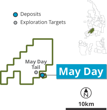
In 2009, Peel finalised the acquisition of Mining Lease 1361 and the May Day Pit, as well as the surrounding Exploration Licence 7461 Gilgunnia.
Following the acquisition of the Mining Lease, Peel undertook numerous geophysical surveys, including gravity surveying, induced polarization and airborne magnetic data remodelling. This exploration highlighted a moderate to strong chargeable IP anomaly and deep magnetic anomaly associated with the May Day deposit.
In 2012, CBH Resources Limited signed a farm-in agreement to acquire 50% of the Mallee Bull and May Day projects. While numerous drilling programs were undertaken during this partnership in the adjacent Exploration Lease 7461, relatively limited exploration was done on the Mining Lease 1361 during this time.
In 2020, Peel exercised its pre-emptive right to acquire CBH Resources Limited’s 50% share of the Mallee Bull/ May Day Joint Venture by matching a third party’s unconditional offer, regaining complete control over the Mallee Bull and May Day projects.
At the same time as this, Peel began undertaking an extensive drilling program of the deposit in 2020, with a total of 59 drillholes completed within the year. The result of this program was a maiden mineral resource for the May Day deposit which was released in 2021. This was subsequently remodelled and updated in 2023, with a new resource being released further increasing the size of the deposit.
Since acquisition of the May Day Mining Lease in 2009, Peel has completed 92 assorted drillholes at the prospect, consisting of 22 RAB drillholes, 54 RC drillholes and 16 diamond drillholes. Exploration drilling at the prospect totalled approximately 1197m of RAB drilling, 11161m of RC drilling, and 1988m of diamond drilling.
Other exploration activities completed by Peel during it’s tenure include soil and rock chip sampling (including lab assay as well as portable XRF), geological mapping, and a number of geophysical survey techniques.
The May Day deposit is located in the southern part of the Cobar Basin, which was developed as four deep-water troughs bordering shallow-water shelves. The southern part of the basin is covered by the Mount Hope and Rast Troughs, which were filled with sediments, volcaniclastics, and volcanics of bi-modal nature.
Mineralisation at May Day occurs as a steeply dipping zone of highly altered, sheared and partly brecciated siltstone and volcaniclastics. Primary mineralisation identified in deeper drilling (100-250m below the surface) comprises pyrite, pyrrhotite, sphalerite, galena, chalcopyrite, tetrahedrite with gold and silver considered to occur within both galena and tetrahedrite. The sulphides occur within a low grade disseminated zone up to 30m wide with local massive sulphide concentrations. Massive sulphides form steeply dipping discrete tabular bodies and are commonly associated with quartz veining and silicification. The sulphides show evidence of recrystallisation and remobilisation. Within about 70m of surface, mineralisation has been affected by weathering and secondary enrichment to produce a gold and silver-rich zone approximately 300m long and 30m wide, with significant amounts of copper, lead and zinc.
A Maiden inferred Mineral Resource Estimate being released in March 2020, followed by an upgraded indicated Mineral Resource Estimate released in March 2021 and subsequently again in January 2023. The 2023 model comprises 1.61 million tonnes at 0.98 g/t gold, 25 g/t silver, 0.92% zinc and 0.61% lead containing approximately 51,000 ounces of gold, 1,300,000 ounces of silver, 14,800t zinc and 9,800t lead.
Refer to 9th January announcement “20MT Resource Base for South Cobar Project” for further details.
The MRE has been reported in accordance with the JORC Code (2012 Edition) and is above A$80/tonne NSR cut-off and utilises mineable shapes, which include minimum mining widths and internal dilution to bound the MREs, except for May Day Open Pit which utilised $40 and $50/t NSR cut-offs for oxide and sulphide Resources within an optimal pit respectively. Figures are rounded to reflect the precision of estimates and include rounding errors.